Where did the heavy snowstorm in Northeast China come from? It caught people off guard
News source: 地球知识局
Published on: 2023-11-08 08:21:29
Tip: News opinions do not represent the position of this website

Towards the end of the year, the largest cold wave this year has quietly arrived. The front line of the cold wave is advancing from Xinjiang to North China and Central China, and it is visible to the naked eye. Starting from the 4th of the month, strong winds, rain and snow occurred in many places in the north, with temperatures dropping as high as 12-16°C, which really caught people off guard.
The Northeast receives its first heavy snowfall
(Picture: ST)▼

This cold wave has two major characteristics: one is that it continued to be warm before, with more water vapor in the air, and the cold air turns into large-scale rain and snow when it goes south; the other is that there is a huge contrast between before and after. In Beijing, it was summer a few days ago The temperature is in the single digits within a week, and the intuitive feeling is that "winter comes with one click".
Beijing is just the “appetizer”. Currently, the area affected by the cold wave that attracts the most attention is the Northeast. All this can be understood just by looking at the data.
"Enter winter in one click" in Northeast China
(Picture: twitter)▼


Since the 5th (Sunday), most of the Northeastern region has experienced intense snowfall or rain-to-snow processes from the northwest to the southeast. Snowfall has been most intense in central and western Jilin, southern and eastern Heilongjiang, and many areas have reached heavy snowfall. Blizzards (10-30 mm of snowfall in 24 hours) or even severe blizzards (more than 30 mm).
Among them, the maximum snowfall in Harbin in 24 hours was 30.1 millimeters, breaking the single-day extreme value since the observation record. The snow accumulation reached 24 centimeters, breaking the November observation record extreme value; while the snow accumulation in Jiamusi and Shuangyashan in eastern Heilongjiang reached 46 centimeters. centimeter.
Heavy snowfall hits most of the Northeast
Heavy snowfall hits Harbin and other cities
(Picture: Central Meteorological Observatory)▼

So, how did this extremely heavy snowfall form in the Northeast? What kind of bad weather will we need to pay attention to in the future?
The underlying geographical logic of the cold wave
The game’s video account has posted popular science videos before
Click on the video below to watch
Ice and Fire:
The direct cause and further tracing of heavy snowfall
The most direct cause of this heavy snowfall came from a rapidly developing frontal cyclone. This cyclone was generated near the Shandong Peninsula on Sunday, and then quickly moved northeastward near the Northeast region. During this movement, it was significantly intensified. According to observation data, the central pressure of this cyclone dropped by about 15hPa within 24 hours ( hPa).
On the evening of November 6, satellite cloud images of cyclones affecting the Northeast region
(Picture: Sunflower 9 satellite)▼

Comparison of national surface weather maps at 14:00 on November 5 and 14:00 on November 6
The purple area is a windy area with sustained wind strength exceeding level 6▼

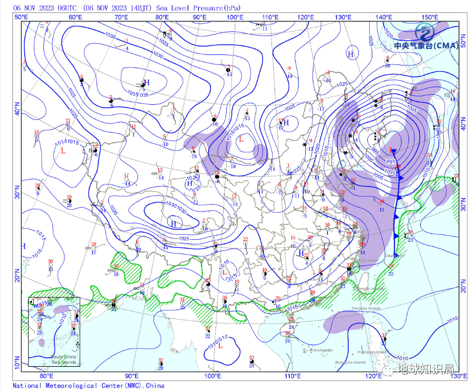
Although this development rate is still slower compared to the crazier "bomb cyclones" in the North Atlantic and other places, it still brings abundant warm and moist airflow from the south into the core area of the cyclone, which is combined with the cold air brought by the cold high pressure from the north. The advection meets, and driven by the strong upward motion provided by itself, it lifts and condenses, falling majestic snowfall between the white mountains and black water; and the strong wind brought by the cyclone forms phenomena such as wind-blown snow and white-haired wind, which intensify in areas with the most extreme snowfall. A disaster.
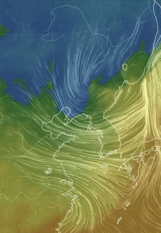
Low-altitude wind field streamlines and temperature color map on November 6, Beijing time
You can see the significant warm and humid air flow northward and the cold advection roaring down
Meet in the eastern part of the Tohoku region▼
And if we further trace the origin of the numerous changes, we will find that this cyclone originated from the echo of a roar in the Atlantic Ocean thousands of miles away.
From November 1st to 2nd, the United Kingdom, Ireland, western and northern France and other places were hit by an unusually powerful frontal cyclone rushing from the North Atlantic. Among them, many places in southern Britain hit record lows in air pressure since observation records were recorded (while London recorded the second lowest value in history), and many places in the Brittany Peninsula in western France experienced gusts of magnitude 12 or above, causing relatively serious disasters. But its influence goes far beyond the western end of Eurasia—its cry will echo in the vast mountains and rivers on the other side of the continent.
Severe cyclone affecting Western Europe on November 2
(Picture: Sentinel-3 satellite)▼

The mid- and high-latitude sea areas of the North Atlantic are very conducive to the development of such strong frontal cyclones - the westerly belt serves as the "intersection" between the polar cold air masses in the north and the warm and moist air masses in low latitudes in the south, where the background pressure gradient and wind jet stream are very Strong, and the temperature gradient between the sharp transition between cold and warm also contains huge baroclinic energy. This background energy is very conducive to the rapid development of local disturbances such as frontal cyclones.
More importantly, the North Atlantic warm current rushing northward brings warmer surface water to this area of the ocean, in which the evaporated water vapor and the latent heat rising from the sea to the atmosphere heat more - this can also promote the surface It is an important mechanism of atmospheric warming, large-scale uplift and pressure reduction, thus supporting the rapid intensification of cyclones.
The global climate affects the whole body
The warm North Atlantic current causes frontal cyclones to grow rapidly
Eventually it brought a blizzard to the other side of Eurasia▼

Strong North Atlantic Warm Current
Continuously transporting large amounts of heat to Europe▼

At the same time, these cyclones also become transient disturbances that develop instability within the westerly belt. With the help of long rivers in the westerly belt, they will transfer their energy faster to the east side of the downstream area - called the dispersion effect in meteorology.
So, stimulated by the strong cyclone that hit Western Europe in early November, a series of new waves formed and swept eastward along the westerly belt across the Eurasian continent. First, it takes the lead in forming a new high-altitude warm high-pressure ridge on the east side of the Ural Mountains. Under the influence of the northerly airflow on the east side of this new high-pressure ridge, the Central Siberian vortex that had been entrenched for a long time was pushed eastward and southward, and entered the northern Xinjiang area of my country on November 4.
November 2-7
Central Siberian Vortex (blue rotating area in the picture)
Starting from northern Xinjiang and sweeping east to south across most of northern my country
(Picture: ECMWF)▼

This vortex itself carries extremely cold air masses, which not only brings cold wave effects to a wider area across the country, but also directly provides cold advection support for the subsequent formation of cyclones that affect the Northeast region.
More importantly, the vortex itself is a deep high-altitude low pressure, which will attract the surface and low-altitude airflows to rise significantly. This is the most direct reason for the rapid decline of surface air pressure and the direct formation of cyclones from the perspective of atmospheric movement and dynamics. .
In addition to the support of the cyclone main body and cold air from the low vortex in the north, the water vapor source provided by the warm and moist airflow in the south is also an important cause of heavy snowfall in the Northeast. This is related to the southern branch trough that moves eastward in the subtropical region during the same period. From Sunday to Tuesday, there is a southern branch trough that moves from west to east and passes over the Jiangnan region of my country. It is just south of the low vortex and overlaps with each other. .
Extremely cold air masses brought by the Central Siberian Vortex
and the warm and moist water vapor transported by the south branch channel moving eastward
Bringing significant cooling, rain and snow weather to northern my country▼

As a result, the southwesterly wind in front of the South Branch Trough (on the east side) can transport a large amount of water vapor from the South China Sea, East China Sea and other places to the northeast and merge into the cyclone, becoming the other half of the driving force for heavy snowfall.
Beyond the Snow:
A brief overview of upcoming weather and winter climate trends
As this northeastern cyclone moves further eastward and weakens, the main body of heavy snowfall in the Northeast has tended to end. But today and tomorrow, there will be a "brief return" of snowfall in the central part of Northeast China - similar to the previous process, this is the dispersion effect of another round of cyclone development from the upper reaches of the North Atlantic-Western Europe to Northeast Asia, triggering了新的冷性涡旋东移。
但与先前不同的是,本次冷性低涡缺乏水汽配合,因而主要为直接的降温而不会再带来显著灾情,这次“返场降雪”也将在明日结束。不过这个冷性涡旋在随后会给我国大部带来新一轮强冷空气过程,在前期已然降温的基础上,气温会进一步显著下降,众多地区气温将创下下半年新低,需要注意防寒保暖。
瑟瑟发抖
未来几天气温将再创新低
(图:中央气象台)▼


而这场强降雪是否预示着东北地区以至于全国冬季的气候状态?这一点并不能。这类极端天气过程的持续时长(数日)、影响范围(百万平方千米量级)相比于总体的气候趋势都要小很多,也主要是短期天气因子所主导。
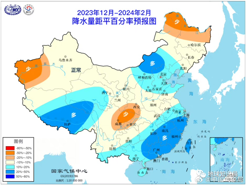
而要分析整个冬季气候趋势,需要考虑影响的时空尺度都更长的气候因子——根据国家气候中心的预测,受今年较强的厄尔尼诺事件、中高纬度积雪海冰等因子影响,全国冬季更可能总体呈现偏暖、中东部大部降水偏多的格局。
送走了突如其来的大风降温和雨雪天气
今年大概率会迎来一个相对温和湿润的冬季
(图:中国气象局)▼

骤雪已然远去,而风云流转永不停息。希望本次受灾区域能尽早恢复。
Click:38 clicks